THIRTY-EIGHT DEGREES FIFTY-SEVEN MINUTES SIX POINT FIVE SECONDS NORTH
SEVENTY-SEVEN DEGREES EIGHT MINUTES FORTY-FOUR SECONDS WEST.
The information was gathered and transmitted undergruund to an unknown location. x Does Langley know about this? They should: it's buried out there somewhere.
...
Thirty-eight degrees fifty-seven minutes six point five seconds north, seventy-seven degrees eight minutes forty-four seconds west.
Therefore, I endeavoured by hook or by crook to get high-enough resolution airphoto imagery that we could plot the coordinates and see if they correlated with any known Kryptos-related features.
Using my own software (Visual Nature Studio 2) I plotted the coordinates against a 1-foot per pixel color orthophoto. The coordinate registration of this photo is believed to be very high quality, having been produced under government contract to the USGS.
There are three datums that are common to locations within the continental USA: NAD27 (old -- defined in 1927), NAD83 (very common, 1983) and WGS84 (also common). WGS84 is the datum commonly used by GPSes (although many GPSes allow you to select from many datums). WGS84 is for most purposes _identical_ to NAD83. NAD83 was defined for the continental US by the American government. WGS 84 was defined a year later for the entire globe by a more global consortium.
For our purposes, we can consider WGS84 and NAD83 equivalent. I tested both and they plotted to exactly the same location.
So, I created two markers interpreting the same coordinates in WGS84/NAD83 and in the older NAD27. It is my belief that any coordinates specified by a CIA-related writer in 1990 would have been specified in NAD83/WGS84. The CIA was one of the groups involved in defining these new datums in 1983/1984, so they would likely be using them by 1990.
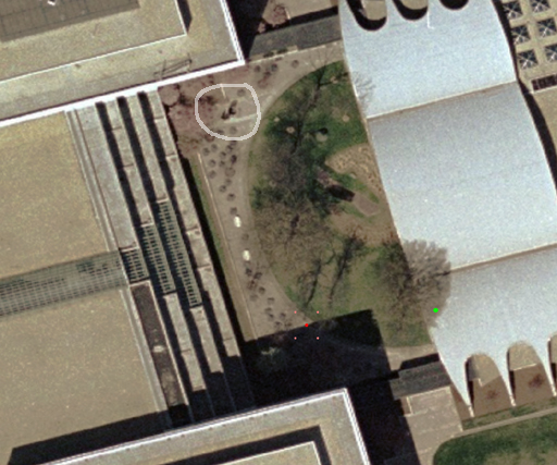
The Kryptos sculpture itself is within the light-colored circle in the northwest corner of the courtyard. It is clearly visible, and its height can be seen by the magnitude of the shadow it casts.
The red dot surrounded by four pink dots in the southern part of the courtyard is the NAD83/WGS84 plot. The green dot to the east (plotted on the arched white cafeteria roof) is the NAD27 interpretation. This odd location immediately suggests that this interpretation is incorrect, reinforcing my original NAD83/WGS84 theory.
I believe based on my data sources that the accuracy of this plot is probably in the 1m (3 foot) range. The original coordinates were specified in Degrees, Minutes, Seconds notation (38° 57' 6.5"N, 77° 8' 44"W) as opposed to decimal degrees (as in 38.9518056°N, 77.1455556°W). Notably, the seconds portion of the Latitude has a decimal component, specifically 6.5" N. This .5 tells us to some degree (pun!) what the level of precision of the coordinate is.
The four pink dots surrounding the red dot are permutations of the coordinate by one tenth of a second on both axes. So, if the location in question had moved just 3 meters in any direction, the seconds coordinate would have increased or decreased by one tenth. This allows us to bound the error magnitude of the location.
How does one get a positional fix of this accuracy? Either by surveying or by GPS. Consumer grade GPS has trouble getting this level of accuracy even today, with accuracy degradation turned off and the benefit of modern 12-channel receivers. However, in 1990 the CIA certainly would have had access to the military grade GPS systems which can deliver this level of accuracy. GPS-determination of the location adds further weight to the WGS84 datum theory.
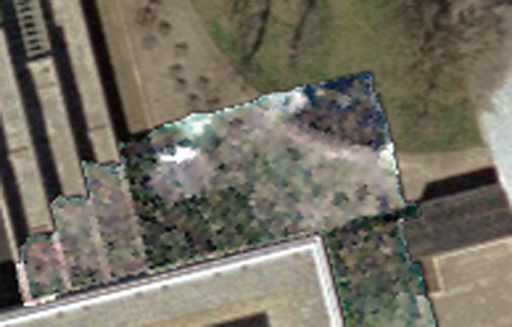
Nothing significant seems apparent -- more of the same small objects scattered about. I believe these are probably cafe-type tables? Perhaps someone who has been there can comment.
What to make of this? I think if anyone can visit Kryptos in the future they should conduct a thorough examination of the area surrounding the red dot. There may be an inscribed walkway tile, or other artifact that might indicate something. The location of the red dot is pleasingly symmetric to the location of Kryptos and its whitish inlay/walkway features, which seems like it is not a coincidence.